ORTELIUS, ABRAHAM: MAP OF FRIULI, VENETIA AND ISTRIA
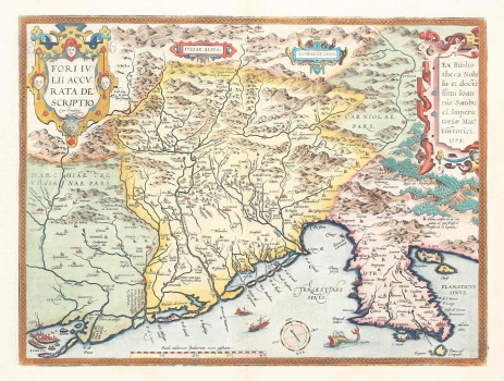
This is a very decorative map of the Friuli (Venezia Giulia) in the middle of Veneto and Venice itself in a protected lagoon in the west, the Italian Alps in the north and the Istrian peninsula in the east. It was produced according to a lost map of Johannes Sambucus sent to him in 1573, in which the author put a note in the cartouche on the right edge of the map. Some researchers attribute this map to Sambucus, and Ortelius is only labeled as an Atlas publisher. This is argued by Sambucus's specialization in navigation charts, for which some parts of the displayed mainland were more susceptible to distortion (Kozličić, 131). The inscription Clana, confin de la Cor: | uatia, et qui finisce il | confin de la Iapidia, stretches in Vinodol, which refers to the border of Croatian lands on the western slopes of Obruča towards Klana. It is the historical, natural-geographic and ethnic boundary of the Roman Littoral towards the Illyrian tribe of Japodi in the mountainous zone. The Istrian coast is more heavily distorted, especially its eastern side and the Kvarner islands, which Ortelius apparently took over from German and Austrian templates, and not from Coppo or more recent ones. Venice is shown in the lower left corner with a detailed panoramic view in the bird's-eye view. The richly decorated title in Renaissance cartouche, typical for Ortelius' atlases, is in the upper left corner. The compass cross and the graphic scale are located at the bottom edge. The map was a part of the first modern atlas, as a systematic collection of maps of the same dimensions (Theatrum Orbis Terrarum) by Abraham Ortelius, although Mercator did not use the term atlas until 20 years later. The first issue of the atlas was published in 1570 and, in addition to Latin, it was reprinted 31 times, with translations from German and Flemish to English, French, Italian and Spanish and grew to 167 maps. This is one of a series of cartographic specimens like Ptolemy's maps of 1596, with almost identical graphic representation and spatial coverage. Symbols also reflect the same timeline. Equipment such as graphic scales and decorative ships match, too. Similar examples are Bertelli's map from 1573 or a map from the Venetian edition of Ptolemy’s Geography from 1596. In contrast to the omissions on the east coast, this map records Croatized toponyms in Istria, such as NOVIGRAT instead of CASTEL NOVO. The reason is that Ortelius, just like the rest of the time, already takes up some of the information from Coppo's 15th-century Istrian template, which is particularly related to linguistic novelties.
ORTELIUS, ABRAHAM
