MÜNSTER, SEBASTIAN: THE 5TH MAP OF EUROPE
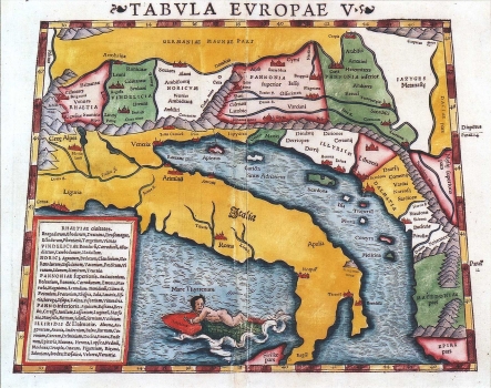
This Ptolemy's 5th map of Europe belongs to Ptolemy's Geographia edited by Münster. It shows the Roman provinces of Rhaetia, Vindelicia, Noricum, Lower and Upper Pannonias, Illyricum and Dalmatia. The ancient names of Illyirian peoples and their settlements are written down on the region that covers the territory of today's Croatia. The topography is shown with ranges of shaded molehills that reach from the Alps to Albania, depicting the mountain system of the Dinaric Alps separating Dalmatia from Pannonia. From the rivers that flow across the territory that covers today's outline of Croatia, the map features Sava, Drava, Krka and Neretva. The islands shown along the Adriatic cost are Cres (Apsorus), Krk (Curicta), Rab (Arba), Murter (Scardona insula), Vis (Issa), Trogir with Ćiovo (Tragurium), Hvar (Pharia), Korčula (Corcyra) and Mljet (Melitina). Index of names arranged by province is in the lower left corner.
MÜNSTER, SEBASTIAN
