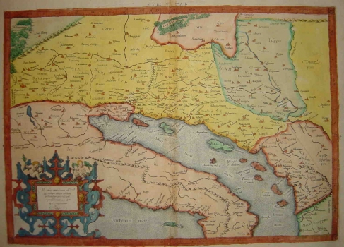
MERCATOR (KREMER), GERHARD: THE FIFTH MAP OF EUROPE
Inventory number 268
Author: MERCATOR (KREMER), GERHARD
Original title: Europa V Tabula
Publishing year: 1584
Place of publishing and publisher: Köln
Format: 32,2 x 45,8 cm
Technique: Coloured copper engraving
This is the famous Fifth map of Europe produced around the turn of the first/second century by the Alexandrian cartographer Klaudius Ptolemy. After the rediscovery of Ptolemy’s Geographia in the 15th century, many editions of this work appeared during the Renaissance period. One of the most famous of its issues was that published in 1584, by already famous, Dutch cartographer Gerhard Mercator. The first issue of Ptolemy’s atlas edited by Mercator was published in 1578, and this example comes from the unchanged second edition published in 1584. Wishing to update his map, Mercator improved the original Ptolomy’s representation of the Roman provinces Rethia, Vindelicia, Noricum, Lower and Upper Pannonia, Illyricum and Dalmatia.
MERCATOR (KREMER), GERHARD
One of the most prominent Dutch cartographers, beside Ortelius, is surely GERHARD KREMER, best known as GERHARD MERCATOR (1512-1594). In distinction from its Dutch contemporaries he produced his atlases and maps by himself. Generally, he fought methods of drawing maps upon sources consisting of somebody else's map images or written documents, while he wanted to make a map applying mathematical and geodetic principles. In 1569 he published his world map made using the projection that took his name (the projection of Mercator) - a novelty which was, in fact, the biggest Mercator's contribution to the world's cartography. His heirs published the complete version of his atlas, in 1595, entitled "Atlas sive Cosmographicae". Prior to this atlas, a number of smaller sets of maps were issued during Mercator's lifetime. Especially valuable are his maps of the New World showing new discoveries. As Mercartor gave his entire attention to the Western Europe and the New World, for drawing of the Croatian lands he was mostly using numerous older sources, which is to be seen from the inscription of medieval state and county boudaries. His maps of "Slavonia, Croatia, Bosnia cum Dalmatiae parte" and Karstia, Carniola, Histria et Windorum Marchia" show the image of the Croatian lands before the Turkish invasion. His atlas went through some forty editions.
