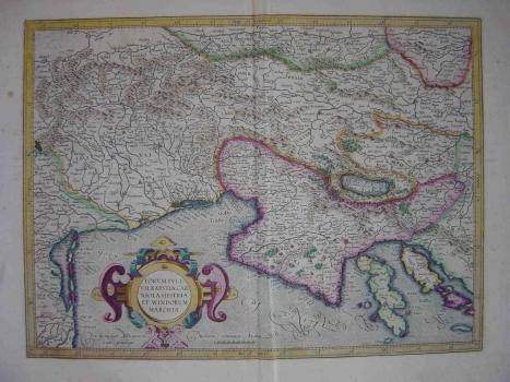
MERCATOR (KREMER), GERHARD: MAP OF FRIULI, KARST, CARNIOLA, ISTRIA AND SLOVENIAN MARK
Inventory number 214
Original title: Forum Julium, Karstia, Carniola, Histria et Windorum Marchia
Publishing year: 1595
Place of publishing and publisher: Duisburg
Format: 35 x 47 cm
Technique: Coloured copper engraving
This Mercator's map comes from the atlas “Atlas sive cosmographicae meditationes de fabrca mundi et fabricati figura”, published one year after his death. This atlas by Mercator is the first collection of maps to bear the title of “atlas” which became afterwards a common name for any collection of maps bound together. Besides Friuli, Carniola and Karst, the map shows all of Istria with the bay of Kvarner. The coastal line of Istria shows many inaccuracies and so do the contours of the Kvarner-bay islands - Cres (Cherso), Lošinj (Lezin), Krk (Veglia) and Rab (Arbe). The flows of the Istiran rivers: Raša, Mirna and Dragonja are oversized. The channel of Lim is wrongly shown as river (Leme fl.). In the inland zone of Istria the mountainous massifs of Ćićarija and Gorski kotar are highlighted with drawings of molehills. The title of the map is in the lower left corner contained within a sumptuous late-Renaissance cartouche. The mileage scale is given in ordinary Italian miles (Miliaria communia Italica).
MERCATOR (KREMER), GERHARD
One of the most prominent Dutch cartographers, beside Ortelius, is surely GERHARD KREMER, best known as GERHARD MERCATOR (1512-1594). In distinction from its Dutch contemporaries he produced his atlases and maps by himself. Generally, he fought methods of drawing maps upon sources consisting of somebody else's map images or written documents, while he wanted to make a map applying mathematical and geodetic principles. In 1569 he published his world map made using the projection that took his name (the projection of Mercator) - a novelty which was, in fact, the biggest Mercator's contribution to the world's cartography. His heirs published the complete version of his atlas, in 1595, entitled "Atlas sive Cosmographicae". Prior to this atlas, a number of smaller sets of maps were issued during Mercator's lifetime. Especially valuable are his maps of the New World showing new discoveries. As Mercartor gave his entire attention to the Western Europe and the New World, for drawing of the Croatian lands he was mostly using numerous older sources, which is to be seen from the inscription of medieval state and county boudaries. His maps of "Slavonia, Croatia, Bosnia cum Dalmatiae parte" and Karstia, Carniola, Histria et Windorum Marchia" show the image of the Croatian lands before the Turkish invasion. His atlas went through some forty editions.