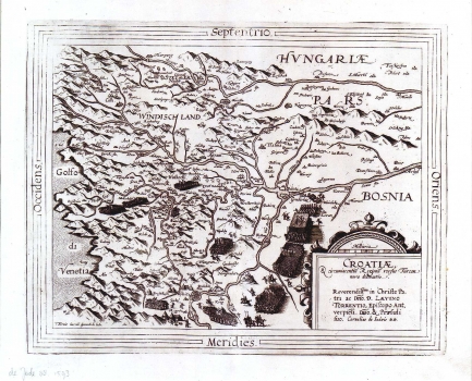
DE JODE, GERARD: MAP OF CROATIA
Inventory number 61
Original title: Croatiae et circumiacentium Regionum versus Turciam nova delineatio. Reverendissimo in Christo parti as Domino Laevino Torrentio, Episcopo Antverpiensi. Domino et Praesuli suo
Publishing year: 1593
Place of publishing and publisher: Antwerpen
Format: 34 x 41 cm
Technique: Copper engraving
The map shows the disposition of forces just before the battle of Sisak of 1593. On the Croatian territory are shown important formations of troops, the Turkish ones around the river Una, and Christian ones around the river Kupa. This is historically very interesting map because it shows the smallest territorial size of Croatia ever occurred. Although, the delineation of new Turkish boundaries is not indicated, they are demarcated by a crescent put on the fortifications conquered by Turks. Čazma is marked as the farthest western stronghold of Turks, and south of Sava there are Hrastovica and Drežnik conquered in 1592. Judging from the actuality of its content, it is obvious that this map was made after some Habsburg military report or military sketch. The lower right corner Renaissance cartouche contains the title. This map is from the atlas edited by Cornelis de Jode.
DE JODE, GERARD
GERARD DE JODE (1509-1591), a famous Dutch graphic artist, printer, publisher and cartographer. While he was preparing his world atlas, from 1555 de Jode was also issuing single maps: in 1560 he published Jacob Gastaldi's Great World Map, in 1563 the Map of Portugal, in 1564 Ortelius' World Map, and in 1569 a series of maps of German regions. Then Ortelius and de Jode had become tough business rivals. But, although he was 18 years older, de Jode was never that businesslike publisher as Ortelius. De Jode published in 1578 his atlas "Speculum Orbis Terrarum", only eight years after the "Theatrum Orbis Terrarum", Ortelius having obtained a monopoly for that period. The atlas was issued in 2 volumes. The first one contained 27 maps of various states and regions, while the 38 maps of the second volume entitled "Geographicum Germaniae Imperium Repraesentants" represents the German territories. Due to the predominance of Ortelius' issues, during de Jode's life, only two issues of his atlas were published (the second one in 1579). On his death, his son, CORNELIS DE JODE (1568-1600) completed his father's work and was published it in 1593. The new atlas comprising 83 maps was entitled "Speculum Orbis Terrae" . Now, de Jode's atlas is extremely rare (only 12 examples are known).