CAMOCIO, GIOVANNI FRANCESCO: TOWN OF HVAR
Inventory number 506
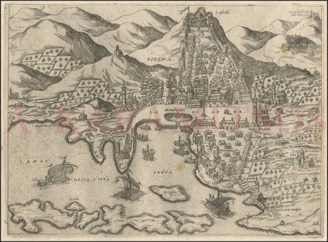
Original title: Liesna
Publishing year: 1571
Place of publishing and publisher: Venezia
Format: 17 x 23,2 cm
Technique: Copper engraving
This view of the town of Hvar shows the main Venetian island harbour of the eastern Adriatic. It was produced in addition to the panoramic map of the entire island of Hvar, which belongs to Camocio's isolario Isole famose, porti, fortezze…(CF Catalogue, No. 507). Although the port is oversized in relation to the surrounding area, the view is so detailed that nearly every residential or communal building can be recognized. The newly built seafront (riua noua) and mandracchio (Mandracchio) are represented realistically. The town is guarded in the hinterland by a castle (Castello), and is protected from the side by ramparts with towers. Newer parts are outside the walls, especially in the west around the church of St. Marko and city port. The main city buildings of the lower part of the settlement (Borgi della citta) are around the square (La piazza); public wells, the Arsenale, the Palazzo di Ragion and the church of San Stefano. Fenced gardens and orchards of the Hvar people are in the hinterland, where there are also recognizable churches and monasteries, La Nouiate San Nicolo and Our Lady of Mercy (S. Maria d. gracie). Pakleni islands are seen in the foreground in front of the Hvar harbour. The plate in the lower right corner is labelled as 16. Although Camocio did not sign this map, it is clear due to the details of this important Venetian port, that he emphasized its importance and demonstrated his own engagement in obtaining new geographic information that had not been recorded on previous maps of Hvar.
CAMOCIO, GIOVANNI FRANCESCO
CAMOCIO, GIOVANNI FRANCESCO (Camocius, Camotio, Cametti, Gioan, Joan Francisco) a Venetian cartographer, publisher and merchant whose most productive period was between 1558 and 1575. He obtained his bookseller's and publisher's licence in Venice in 1552, marked Al segno della Pyramide. His copper-plate engraving workshop produced maps and vedute that as a publisher he was signing with apresso or apud G. F. Camocio cum privilegio. The most fertile period of his artistic production, between the 1550s and the 1570s, was also the peak of the isolarii (depictions of islands) period, especially in Italy. These are detailed, practical, perspective depictions of certain cities and ports, created predominantly in a large-scale copper-plate engraving technique. Unlike earlier portulan charts, these depictions of the maritime area and the inland of the islands were largely based on field work. Along with G. Rosaccio, G. Franco and S. Pinargenti, Camocio was the most significant representative of the tradition. His interest lay on the eastern Adriatic coast where he had his informants and topographers, so he created several maps of the Croatian lands. His most famous works are Lombardija Atlantic from 1560, which he created with Forlani, Dalmatia i Friuli from 1563, Isole Famose from 1563 and 1564, Grčka, Italija i Napulj from 1566, Venecija from 1571 and Europa, published in 1579. His copper plates were passed on to Donato Bertelli. Copper plates were, at the time, passed on, inherited, exchanged and traded, and the information they carried was also often exchanged among cartographers and publishers. His most famous maps of our (Croatian) territories are Novo dissegno della Dalmatia et Crovatia from 1566, Istra from 1569, and he also authored the isolario or atlas Isole famose, porti, fortezze e terre maritimme… from 1571 and 1574, comprising a large number of maps of the Croatian territories, although he did not author all of the maps contained within it. Almost twenty of his maps are depictions of the Croatian Littoral or port vedute, but he only signed some of them, which are most likely the ones he personally refined or updated. His maps of Dalmatia and Istria show that he had access to higher quality topographic templates or data only for some regions, such as Coppo’s map of Istria from 1525. He also published the works by local cartographers, Natalo Bonifaci and Martino Rota, from where he clearly sourced the cartographic information for his own works. He was obviously very skilled in selecting the information he would use, as he tried to correct some frequently repeated errors he had come accross.