CORONELLI, VINCENZO MARIA: ADMINISTRATIVE MAP OF DALMATIA
Inventory number 65
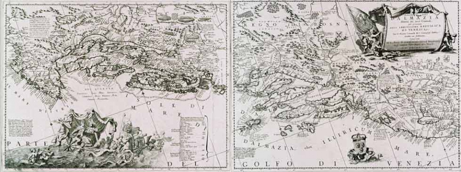
Original title: Ristretto della Dalmazia divissa né suoi Contadi già presentata alla Serenissima Republica di Venezia
Publishing year: 1690
Place of publishing and publisher: Venezia
Format: 2 x: 46 x 60 cm
Technique: Copper engraving
This Coronelli's map was in circulation both as a separately printed map and as a component of his well known atlas “Isolario dell’ Atlante Veneto” dated 1696, as well as of his so called small isolario entitled “Mari, golfi, isole…” dating from around 1700. The map shows the Adriatic coast from Istria to the mouth of the river Bojana and consists of two atlas folios. Coronelli's administrative map of Dalmatia is one of the first thematic maps of Dalmatia showing its administrative-territorial organization as it was after Dalmatia became part of the Venetian Republic. Terrestrial and maritime borders of districts (contadi) are marked. It should be noted that for the maritime district boundaries the time of their establishment is also given. As he was appointed official cartographer to the Venetian Republic, Coronelli chronicled attentively all the battles fought against the Turks occurred in the Dalmatian area a table of which he featured along the lower margin of the western map's folio. There are numerous notes relating to the various land battles fought against the Turks. Besides the settlements and the outline of the administrative-territorial organization of Dalmatia, two caravan roads are marked – so called Split and Dubrovnik roads leading to Bosnia through the Herzegovinian inland zone. Aesthetically, this richly illustrated map is a superb example of Italian baroque mapmaking art.
CORONELLI, VINCENZO MARIA
VINCENZO MARIA CORONELLI (1650-1718). He was the most famous Italian cartographer from the period of the Venetian Republic. He established the society of geographers "Accademia degli Argonauta", one of the oldest in the world. In his cartographer's workshop in Venice he gathered a number of illustrators and cartographers. The Senate of Venice supported their work with large amounts of money, and Coronelli was the first cartographer who had a reputation as an official geographer of the Venetian Republic. His maps, a part of their strategic and economical importance, were also often used as powerful instruments of exaltation of Venice and its victories over theTurks. In delineation of boundaries Coronelli usually indicates the state of things as it was before the Turkish conquests, not recognizing Turkish possessions in Dalmatia. At the same time on all his maps he noted next to various places the names of the Venetian conquests during the Morean war. In the period nearing the end of the 17th century, his maps were used by all the state services of the Venetian Republic. Coronelli was the author of the best Venetian atlases: "Isolario dell'Atlante Veneto" issued in two volumes, also named "The Great Isolario". The other is "Mari, Golfi, Isle, Spiaggie, Porti, Citta…" issued in four volumes named "The Small Isolario" that comprises over 100 port and fortress plans including as well a number of map images of the Croatian coast.