CORONELLI, VINCENZO MARIA: MAP OF DANUBE BASIN
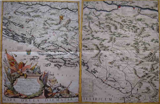
ad a) This map is one of the sheets composing the great Coronelli's map showing the course of Danube from Vienna to Nikopolje comprising 6 copper engraved sheets published in Coronelli's atlas «Atlante Veneto». This sheet shows the part of the Croatian coast of the Adriatic from Karlobag to Dubrovnik, as well as Lika, Krbava and Bosnia. As the map was produced during the Venetian-Turkish war between 1683 and 1699, next to many settlements the annotations are set in stating the year and the outcome of the conflict in question between the Venetian and Turkish forces. The topography is depicted as ranges of shaded molehills not showing the real geographical features of the represented area. The title of the map is in the lower left corner in a baroque cartouche surrounded by military and war symbols of the Ottoman Empire defeated in the aforesaid war by the Venetian Republic.
ad b) This is one of the 6 sheets of Coronelli's great map of the Danubian Bassin under the common title «Corso del Danubio da Vienna sin' ŕ Nicopoli…». As all other sheets this one was also included in Coronelli's atlas «Atlante Veneto». Is shows the area of the eastern Bosnia, Serbia with Kosovo, Montenegro and parts of Albania and Macedonia. Next to a number of settlements there are annotations on war conflicts. Especially interesting are the notes about number of inhabitants and houses in particular settlements. So, we for example we learn that Priština in 1689 had 4 000 inhabitants. In physical-geographical sense Coronelli had no particularly good knowledge of that territory and that is why the relief is shown with many faults. In the lower left corner of the map is the list of settlements together with the date on which they were taken during the war between 1683-1699. Numerous place names indicated on the coast in comparison with only a few of them indicated in the inland area, clearly indicates that the geographical spaces comprised by Venetian Dalmatia that included present-day Montenegrin littoral and the coastal region of present-day Albania were much more familiar to Corelly than the inland zones at that time making part of the Ottoman Empire.
CORONELLI, VINCENZO MARIA
