CORONELLI, VINCENZO MARIA: MAP OF THE ADRIATIC SEA
Inventory number 95
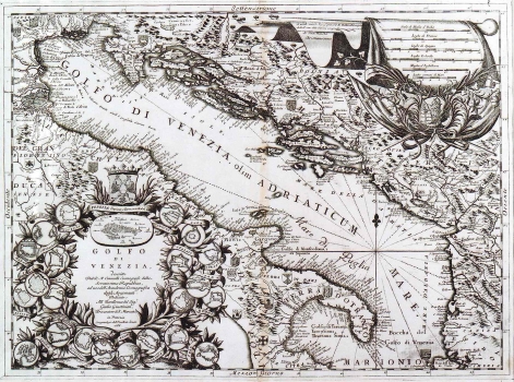
Original title: Golfo di Venezia, descritto Dal Padre Minorita Coronelli Cosmografo della Serenissima Republica, ad uso dell’ Accademia Cosmografica degli Argonauti. Dedicato All’ Eccellenza del Signor Giulio Giustinian, Procuratore di San Marco, etc. in Venezia Con privilegio dell’ Eccellentissimo Senato
Publishing year: 1688
Place of publishing and publisher: Venezia
Format: 45 x 60,5 cm
Technique: Copper engraving
This map was issued in Coronelli's Small Isolario "Mari, golfi,isole…" published in Venice in 1702. The map shows part of Croatia south of the river Sava and the whole Dalmatia with Istria. In accordance with the title of the map the emphasis is given to the representation of coastal profiles, ports and golfs. Numerous maritime town plans placed around the map's title cartouche also witness about this orientation. From the Croatian places surrounding the cartouche we note the plans of the following towns: Pula, Senj, Split, Korčula, Šibenik, Zadar, Trogir, Hvar and Dubrovnik. Alike the title, a mileage scale is presented in a very attractive cartouche with a prominent representation of the Venetian lion below it. The mileage scale is in Italian, French, Spanish, German, English and nautical miles.
CORONELLI, VINCENZO MARIA
VINCENZO MARIA CORONELLI (1650-1718). He was the most famous Italian cartographer from the period of the Venetian Republic. He established the society of geographers "Accademia degli Argonauta", one of the oldest in the world. In his cartographer's workshop in Venice he gathered a number of illustrators and cartographers. The Senate of Venice supported their work with large amounts of money, and Coronelli was the first cartographer who had a reputation as an official geographer of the Venetian Republic. His maps, a part of their strategic and economical importance, were also often used as powerful instruments of exaltation of Venice and its victories over theTurks. In delineation of boundaries Coronelli usually indicates the state of things as it was before the Turkish conquests, not recognizing Turkish possessions in Dalmatia. At the same time on all his maps he noted next to various places the names of the Venetian conquests during the Morean war. In the period nearing the end of the 17th century, his maps were used by all the state services of the Venetian Republic. Coronelli was the author of the best Venetian atlases: "Isolario dell'Atlante Veneto" issued in two volumes, also named "The Great Isolario". The other is "Mari, Golfi, Isle, Spiaggie, Porti, Citta…" issued in four volumes named "The Small Isolario" that comprises over 100 port and fortress plans including as well a number of map images of the Croatian coast.