BORDONE, BENEDETTO: CHART OF HVAR, KORČULA, BRAČ, LASTOVO AND PELJEŠAC
Inventory number 49
Original title: Brazza, Lieczena, Curzola/ Benedetto Bordone Curzola, Lagustra, Sabioncello/ Benedetto Bordone
Publishing year: 1532
Place of publishing and publisher: Venezia
Format: 8,5x14,5 cm
Technique: Wood-cut
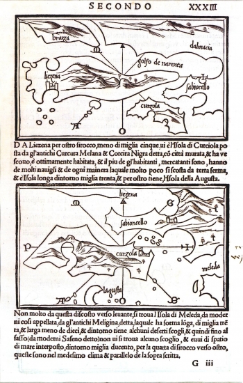
Map sheet XXXIII of Bordone's Isolario comprises two separated representations. The first one representing the island of Hvar together with the islands of Brač, Korčula and a part of the southern Dalmatia with the peninsula of Pelješac. The topography of the island of Hvar is shown arbitrarily by roughly drawn and shaded molehills. In the southwestern part of the island is to be seen the Bay of Hvar enlarged in proportion with the town of Hvar. In the north the area of focus of the engraver are the Bay of Starigrad and the indented western island's coast. The map is oriented by a wind rose. Following the northwestern wind maestral one reaches the island of Brač, navigating in an easterly direction (Levant) the peninsula of Pelješac, and in a southeasterly direction (Široko) lies the island of Korčula.
BORDONE, BENEDETTO
BENNEDETTO BORDONE (1460-1531), an Italian cartographer and graphic artist native from Padua. He became famous for his isolarios (books of sea-charts). The first edition of his most famous work was published in Venice in 1528. The title of his work is "Isolario di Benedetto Bodone Nel quale si ragiona di tutte l'isole del mondo, con li lor nomi antichi e moderni, historie, favole, e mondi del loro vivere, e in qual parte del mare stanno, e in qual parallelo e clima giaciono. This nautical chart atlas went through several editions (1532, 1534, 1537, 1547). The map images in Bordone's Isolario are made on Bartolomeo dalli Sonetti's sources as he published a very similar isolare in Venice in 1485.