Hrvatski Deutsch English
Home Maps a-e DE JODE GERARD Fluvii Danubis Tractus
DE JODE, GERARD: MAP OF THE DANUBE BASIN

DE JODE, GERARD: MAP OF THE DANUBE BASIN

Inventory number 107
Original title: Fluvii Danubis Tractus / Cristian Sgrooten
Publishing year: 1593
Place of publishing and publisher: Antwerpen
Format: 33,5 x 49,5 cm
Technique: Coloured copper engraving

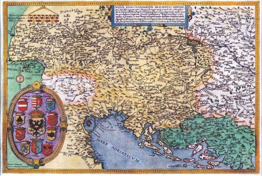
The map of the Danubian basin by Christian Sgrooten (approx. 1532-1608), a Dutch geographer and cartographer that was issued in the atlas edited by Cornelis de Jode. It consists of two sheets, and this is its part covering the west. In the representation of the Croatian lands some gross errors were made. The area to the west of Zagreb is named as "Windisch landt" (Slavonija), and the part to the south of the river Sava as "Croatia". Krbava ("Carbavatia") was wrongly placed in the coastal area between Senj and Split. The zone of the Dalmatian hinterland from Split to Dubrovnik he named "Sclauonisch landt", while to the northeast from Dubrovnik according to Sgrooten there was "Dalma" (Dalmatia). In additon to this, the names of the Roman provinces of Pannonia Inferior and Pannonia Superior are also indicated, what could lead to the conclusion that Sgrooten based his representation of the Croatian lands on the sources dating back to Antiquity. Coastal profiles are hardly recognizable. The island of Pag is represented in front of the town of Zadar, while a strip of land is connecting Pelješac and Korčula. In the lower left corner of the map there are coat of arms of Austria, Hungary, Erdelj, Bosnia, Wallachia, Bulgaria, Turkey, Bosnia, with House of Habsburg's coat of arms in the center. To the left of the cartouche are written the names of engravers: Ioannes a Deutecum, Lucas a Deutecum Fecerunt. A mileage scale is in the upper left corner in German (Milliaria Germanica), Hungarian (Milliaria Hungarica) and Italian miles (Milliaria Italica).  

DE JODE, GERARD
GERARD DE JODE (1509-1591), a famous Dutch graphic artist, printer, publisher and cartographer. While he was preparing his world atlas, from 1555 de Jode was also issuing single maps: in 1560 he published Jacob Gastaldi's Great World Map, in 1563 the Map of Portugal, in 1564 Ortelius' World Map, and in 1569 a series of maps of German regions. Then Ortelius and de Jode had become tough business rivals. But, although he was 18 years older, de Jode was never that businesslike publisher as Ortelius. De Jode published in 1578 his atlas "Speculum Orbis Terrarum", only eight years after the "Theatrum Orbis Terrarum", Ortelius having obtained a monopoly for that period. The atlas was issued in 2 volumes. The first one contained 27 maps of various states and regions, while the 38 maps of the second volume entitled "Geographicum Germaniae Imperium Repraesentants" represents the German territories. Due to the predominance of Ortelius' issues, during de Jode's life, only two issues of his atlas were published (the second one in 1579). On his death, his son, CORNELIS DE JODE (1568-1600) completed his father's work and was published it in 1593. The new atlas comprising 83 maps was entitled "Speculum Orbis Terrae" . Now, de Jode's atlas is extremely rare (only 12 examples are known).
Print Friendly and PDF
Top