DE JODE, GERARD: MAP OF ILLYRICUM AND SLAVONIA
Inventory number 90
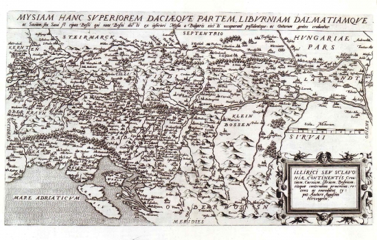
Original title: Illyrici seu Sclavoniae, contentis Croatiam, Carniam, Istriam, Bosniam, eisquae conterminas provincias, recens emendatus typus / auctore Augustin Hirschvogel
Publishing year: 1593
Place of publishing and publisher: Antwerpen
Format: 30 x 51 cm
Technique: Copper engraving
Augustin Hirschvogel (1503-1553), a Habsburg engraver, made this map of Illyricum and Slavonia. It shows the region of Slavonia (Windisch Land) and Croatia with its northern Littoral and Istria. This Hirschvogel's map of Illyricum was issued in the II volume of Cornelis de Jode's atlas of 1593, and represents in fact a revised re-issue of the map "Schlavoniae, Croatiae, Carniae, Istriae, Bosniae.." of the same author, first published by Abraham Ortelius in his atlas "Theatrum Orbis Terrarum". The title of the map is in the lower right corner in a Renaissance cartouche with masquerons and floral decorations. Includes the text placed above the upper margin edge reading: Mysiam hanc superiorem Daciaeque partem, Liburniam Dalmatiamque ac Saviam, seu Savi Fl ripas Bessi dicti ex inferiori Mysia a Bulgaris eiecti occuparunt possidentque: ac getarum gentes creduntur.
DE JODE, GERARD
GERARD DE JODE (1509-1591), a famous Dutch graphic artist, printer, publisher and cartographer. While he was preparing his world atlas, from 1555 de Jode was also issuing single maps: in 1560 he published Jacob Gastaldi's Great World Map, in 1563 the Map of Portugal, in 1564 Ortelius' World Map, and in 1569 a series of maps of German regions. Then Ortelius and de Jode had become tough business rivals. But, although he was 18 years older, de Jode was never that businesslike publisher as Ortelius. De Jode published in 1578 his atlas "Speculum Orbis Terrarum", only eight years after the "Theatrum Orbis Terrarum", Ortelius having obtained a monopoly for that period. The atlas was issued in 2 volumes. The first one contained 27 maps of various states and regions, while the 38 maps of the second volume entitled "Geographicum Germaniae Imperium Repraesentants" represents the German territories. Due to the predominance of Ortelius' issues, during de Jode's life, only two issues of his atlas were published (the second one in 1579). On his death, his son, CORNELIS DE JODE (1568-1600) completed his father's work and was published it in 1593. The new atlas comprising 83 maps was entitled "Speculum Orbis Terrae" . Now, de Jode's atlas is extremely rare (only 12 examples are known).